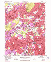
1955 Map of Roselle
USGS Topo · Published 1972About this map
South Mountain Reservation and the Watchung Reservation anchor this densely settled corridor of Union and Essex Counties. The landscape is defined by a complex web of transportation, where the Lackawanna RR, Lehigh Valley RR, and Central RR of New Jersey converge among established suburban centers like Summit, Westfield, and Cranford. The 1955 survey data, updated with 1970 purple-tinted urban extensions, illustrates the rapid post-war growth filling the spaces between historic village cores. Educational and religious institutions are prominent, from Seton Hall University in the north to numerous parochial and public schools like Holy Trinity High Sch and Gaudineer Sch. Leisure and open space are integrated into the suburban fabric via the Baltusrol Golf Course and several municipal parks along the Rahway River and Echo Lake.
Find a feature on this map
120 named features on this map. Tap any name to fly to it.
Don’t see what you’re looking for? This feature index may not catch every label — zoom into the map to look around manually.
Map Details
Editions of this 1955 Roselle Map
4 editions found
Other maps of this area

1888 · Plainfield
USGS Topo · 1:62,500

1888 · Morristown
USGS Topo · 1:62,500

1888 · Paterson
USGS Topo · 1:62,500

1892 · Paterson
USGS Topo · 1:62,500

1893 · Plainfield
USGS Topo · 1:62,500

1894 · Morristown
USGS Topo · 1:62,500

1898 · Morristown
USGS Topo · 1:62,500

1898 · Plainfield
USGS Topo · 1:62,500

1898 · Staten Island
USGS Topo · 1:62,500

1898 · Paterson
USGS Topo · 1:62,500