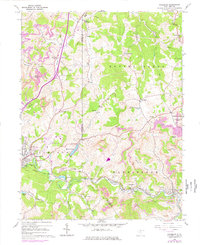
1960 Map of Rosemont
USGS Topo · Published 1978About this map
Benedum Airport anchors the western portion of this Taylor County landscape, reflecting the post-war modernization of north-central West Virginia. The terrain is defined by the valley of Simpson Creek, where the Baltimore and Ohio railroad corridor connects industrial and residential centers like Bridgeport, Rosemont, and Flemington. This survey documents a complex pattern of resource extraction and community growth, with numerous Strip Mines and gas wells interspersed among established settlements and rural landmarks like Harmony Grove Ch and Baileyton Ch. Recreational and residential developments at Maple Lake, Oral Lake, and Deegan Lake highlight the mid-century shift toward suburban living outside the traditional mining and railroad towns. The map also traces the intricate drainage of Stouts Run and Thomas Fork, alongside high points such as Patton Knob and Copeland Knob.
Find a feature on this map
59 named features on this map. Tap any name to fly to it.
Don’t see what you’re looking for? This feature index may not catch every label — zoom into the map to look around manually.
Map Details
Editions of this 1960 Rosemont Map
3 editions found
Other maps of this area

1902 · Clarksburg
USGS Topo · 1:62,500

1902 · Fairmont
USGS Topo · 1:62,500

1904 · Philippi
USGS Topo · 1:62,500

1904 · Weston
USGS Topo · 1:62,500

1910 · Clarksburg
USGS Topo · 1:62,500

1923 · Fairmont
USGS Topo · 1:62,500

1923 · Clarksburg
USGS Topo · 1:62,500

1925 · Clarksburg
USGS Topo · 1:62,500

1925 · Philippi
USGS Topo · 1:62,500

1926 · Fairmont
USGS Topo · 1:62,500