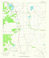
1963 Map of Rosharon
USGS Topo · Published 1966About this map
The Missouri Pacific railroad corridor anchors the Brazoria County landscape, connecting the small settlements of Rosharon and Bonney in the early 1960s. This survey reveals a transition from traditional agriculture, seen at Chenango Plantation, to the mid-century industrial presence of the Bonney Oil Field and numerous gas wells. The western edge is defined by the Department of Correction (Ramsey Unit), while the interior features a complex network of drainage, including the Texas Water Company Canal and Austin Bayou. Social and community life is documented through the presence of the Rosharon School and local spiritual landmarks like Elion Ch and Providence Ch. For genealogists, the map preserves the locations of the Daughters Cem and Pilgrim Cem, situated near the sloughs and lakes that dot the coastal plain.
Find a feature on this map
28 named features on this map. Tap any name to fly to it.
Don’t see what you’re looking for? This feature index may not catch every label — zoom into the map to look around manually.
Map Details
Editions of this 1963 Rosharon Map
2 editions found
Other maps of this area

1943 · Rosharon
USGS Topo · 1:31,680

1943 · Danbury
USGS Topo · 1:31,680

1943 · Juliff
USGS Topo · 1:31,680

1943 · Angleton
USGS Topo · 1:24,000

1943 · Chocolate Bayou
USGS Topo · 1:24,000

1950 · Houston
USGS Topo · 1:250,000

1952 · East Columbia
USGS Topo · 1:24,000

1953 · Otey
USGS Topo · 1:24,000

1953 · Thompsons
USGS Topo · 1:24,000
1956 · Manvel
USGS Topo · 1:24,000