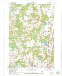
1969 Map of Rosholt
USGS Topo · Published 1990About this map
Rosholt and Galloway anchor this northern Wisconsin landscape as it appeared in the late 1960s, a region defined by a dense concentration of glacial kettles and moraine-fed waters. The village of Rosholt serves as a hub in the southern portion of the sheet, while the smaller settlement of Holt and the town of Alban provide more dispersed residential points. A significant historical industrial mark is left by the Old Grade Railroad, which traces a path through the center of the terrain, indicative of the area's timber-hauling past. This transport corridor passes near several prominent water bodies, including Moss Lake and Stenson Lake. The Little Wolf River meanders across the northern reaches, while the south is punctuated by recreation and community spaces like Peterson Park and Lions Lake. Local industry is further evidenced by several Gravel Pits located near the headwaters of Bradley Creek, reflecting the glacial geology that shaped the county's economy.
Find a feature on this map
26 named features on this map. Tap any name to fly to it.
Don’t see what you’re looking for? This feature index may not catch every label — zoom into the map to look around manually.
Map Details
Editions of this 1969 Rosholt Map
2 editions found
Other maps of this area

1899 · Wausau
USGS Topo · 1:125,000

1902 · Wausau
USGS Topo · 1:125,000

1953 · Hatley
USGS Topo · 1:48,000

1954 · Wittenberg
USGS Topo · 1:48,000

1955 · Tigerton
USGS Topo · 1:48,000

1955 · Rosholt
USGS Topo · 1:48,000

1955 · Green Bay
USGS Topo · 1:250,000

1964 · Wittenberg
USGS Topo · 1:62,500

1964 · Hatley
USGS Topo · 1:62,500

1969 · Rosholt
USGS Topo · 1:24,000