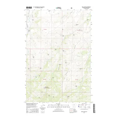
2017 Map of Ross Canyon
USGS Topo · Published 2017About this map
Gallatin National Forest dominates the southern reaches of this landscape, where the terrain rises sharply toward Red Mtn. This 2017 survey by the U.S. Geological Survey details the complex drainage patterns of the Upper Deer Cr and the Boulder River, the latter crossed by the Eightmile Bridge in the northwest. The area is defined by its deep, named ravines and ridges, illustrating a transition from the level McKenzie Flats to the more varied topography of Ross Canyon and Baker Canyon. Local history is embedded in the descriptive names of the gulches, such as Sawmill Gulch, Dead Horse Gulch, and Tomato Can Gulch, which often reflect the early cattle ranching and logging operations that once operated in these foothills. A network of rural routes, including Old Boulder Rd and Slide Rock Road, provides the primary access through this corner of Sweet Grass County.
Find a feature on this map
51 named features on this map. Tap any name to fly to it.
Don’t see what you’re looking for? This feature index may not catch every label — zoom into the map to look around manually.
Map Details
Editions of this 2017 Ross Canyon Map
This is the sole edition of this map. No revisions or reprints were ever made.
Other maps of this area

1891 · Livingston
USGS Topo · 1:250,000

1891 · Big Timber
USGS Topo · 1:125,000

1893 · Livingston
USGS Topo · 1:250,000

1893 · Big Timber
USGS Topo · 1:125,000

1947 · Bozeman
USGS Topo · 1:250,000

1948 · Bozeman
USGS Topo · 1:250,000

1951 · Squaw Peak
USGS Topo · 1:24,000
1951 · Mc Leod
USGS Topo · 1:24,000
1951 · Carney
USGS Topo · 1:24,000

1954 · Big Timber
USGS Topo · 1:24,000