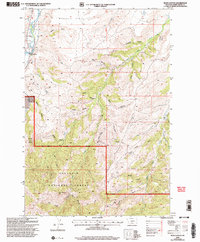
2000 Map of Ross Canyon
USGS Topo · Published 2005About this map
Gallatin National Forest dominates the southern landscape of this Sweet Grass County region, where the terrain transitions from the high peaks of Red Mountain and Black Butte into a complex network of canyons and gulches. The western edge is defined by the Boulder River, a vital water source evidenced by an extensive irrigation system including the Ellison Ditch, Weaver Ditch, and Smoot Ditch. This infrastructure highlights the historical importance of water management in the McKenzie Flats area.
Find a feature on this map
42 named features on this map. Tap any name to fly to it.
Don’t see what you’re looking for? This feature index may not catch every label — zoom into the map to look around manually.
Map Details
Editions of this 2000 Ross Canyon Map
This is the sole edition of this map. No revisions or reprints were ever made.
Other maps of this area

1891 · Livingston
USGS Topo · 1:250,000

1891 · Big Timber
USGS Topo · 1:125,000

1893 · Livingston
USGS Topo · 1:250,000

1893 · Big Timber
USGS Topo · 1:125,000

1947 · Bozeman
USGS Topo · 1:250,000

1948 · Bozeman
USGS Topo · 1:250,000

1951 · Squaw Peak
USGS Topo · 1:24,000
1951 · Mc Leod
USGS Topo · 1:24,000
1951 · Carney
USGS Topo · 1:24,000

1954 · Big Timber
USGS Topo · 1:24,000