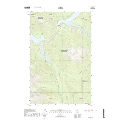
2020 Map of Ross Dam
USGS Topo · Published 2020About this map
Ross Dam serves as the central engineering landmark of this high-elevation wilderness, where it impounds the waters of Ross Lake within the Ross Lake National Recreation Area. The map illustrates a complex network of glacial drainage and peaks, including the steep slopes of Sourdough Mtn and Colonial Peak. A transition from industrial utility to conservation is evident in the presence of the Happy Creek Mill site near the reservoir's edge, contrasted with the protected lands of North Cascades National Park. Long-distance foot travel is represented by the Pacific NW National Scenic Trail as it winds around Ruby Arm and toward Hidden Hand Pass. Lower-elevation features such as Buster Brown Flats and the Woods Nature Tr near Thunder Arm provide specific points of interest for those tracking local land use and recreational development in this mountain corridor.
Find a feature on this map
45 named features on this map. Tap any name to fly to it.
Don’t see what you’re looking for? This feature index may not catch every label — zoom into the map to look around manually.
Map Details
Editions of this 2020 Ross Dam Map
This is the sole edition of this map. No revisions or reprints were ever made.
Other maps of this area

1920 · Slate Pass
USGS Topo · 1:125,000

1955 · Concrete
USGS Topo · 1:250,000

1958 · Concrete
USGS Topo · 1:250,000

1962 · Concrete
USGS Topo · 1:250,000

1963 · Eldorado Peak
USGS Topo · 1:24,000
1963 · Forbidden Peak
USGS Topo · 1:24,000
1963 · Mt Logan
USGS Topo · 1:24,000

1963 · Crater Mountain
USGS Topo · 1:24,000

1963 · Diablo Dam
USGS Topo · 1:24,000

1963 · Ross Dam
USGS Topo · 1:24,000