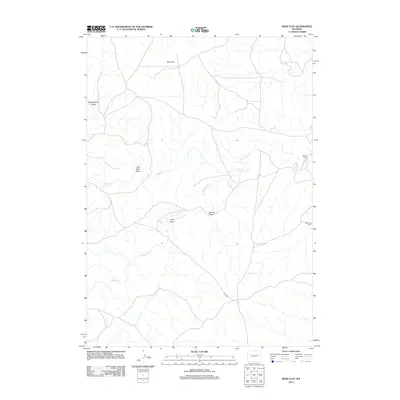
2012 Map of Ross Flat
USGS Topo · Published 2012About this map
Ross Flat defines this expanse of Campbell County, where the high plains are carved by an intricate network of seasonal drainages and creek beds. In the early 21st century, the landscape remains characterized by large-scale cattle ranching operations, marked by the Moore Ranch in the northeast and the WG Taylor Ranch further south. The drainage patterns are dominated by the meandering paths of Antelope Cr and Wind Cr, which converge amidst several named geographical depressions including Bull Gulch and Spring Draw. Access to this isolated territory is primarily facilitated by Ross Rd, a lone thoroughfare crossing the southern portion of the quadrangle. This survey illustrates the persistent ranching tradition in Wyoming, showing how human settlement persists along the edges of natural waterways like Ninemile Cr and within the shelter of various draws such as Red Rock Draw.
Find a feature on this map
11 named features on this map. Tap any name to fly to it.
Don’t see what you’re looking for? This feature index may not catch every label — zoom into the map to look around manually.
Map Details
Editions of this 2012 Ross Flat Map
This is the sole edition of this map. No revisions or reprints were ever made.
Other maps of this area

1954 · Artesian Draw
USGS Topo · 1:24,000

1954 · Pine Tree
USGS Topo · 1:24,000

1955 · Newcastle
USGS Topo · 1:250,000

1958 · Newcastle
USGS Topo · 1:250,000

1959 · Coal Draw
USGS Topo · 1:62,500

1960 · Ross
USGS Topo · 1:62,500

1960 · Turnercrest
USGS Topo · 1:62,500

1974 · Reno Junction
USGS Topo · 1:100,000

1979 · Bill
USGS Topo · 1:100,000
1984 · Marsh Draw
USGS Topo · 1:24,000