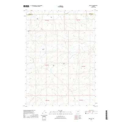
2017 Map of Ross Flat
USGS Topo · Published 2017About this map
Ross Flat defines this northern Wyoming landscape where the boundaries of Campbell and Converse counties meet. The area is characterized by an intricate drainage system, where intermittent streams like Ninemile Cr and Antelope Cr have carved a complex series of draws and gulches into the high plains. The terrain is marked by notable features such as Red Rock Draw and Bull Gulch, illustrating the erosive forces at work in this arid environment. Transportation through this remote section of the Powder River Basin is limited to a few arterial routes, including Nine Mile Creek Rd and Co Rd 31, which connect the scattered rangelands. This 2017 survey reflects the enduring character of the western ranching frontier, where naming conventions like McNaughton Draw and Moyer Draw likely preserve the legacy of early landholders and homesteading families.
Find a feature on this map
18 named features on this map. Tap any name to fly to it.
Don’t see what you’re looking for? This feature index may not catch every label — zoom into the map to look around manually.
Map Details
Editions of this 2017 Ross Flat Map
This is the sole edition of this map. No revisions or reprints were ever made.
Other maps of this area

1954 · Artesian Draw
USGS Topo · 1:24,000

1954 · Pine Tree
USGS Topo · 1:24,000

1955 · Newcastle
USGS Topo · 1:250,000

1958 · Newcastle
USGS Topo · 1:250,000

1959 · Coal Draw
USGS Topo · 1:62,500

1960 · Ross
USGS Topo · 1:62,500

1960 · Turnercrest
USGS Topo · 1:62,500

1974 · Reno Junction
USGS Topo · 1:100,000

1979 · Bill
USGS Topo · 1:100,000
1984 · Marsh Draw
USGS Topo · 1:24,000