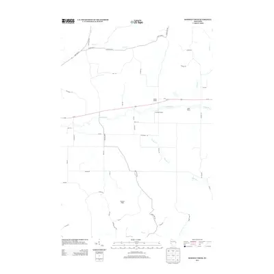
2013 Map of Rossman Creek
USGS Topo · Published 2013About this map
The Buffalo River meanders across this landscape, defining the topography of the central corridor just south of Us-10. The terrain is marked by significant geographic relief, including Bennett Ridge and the distinct depressions of Session Valley and Davy Valley. This 2013 survey illustrates a rural network of roads and family-named routes such as Moe Rd, Wulff Rd, and Allemann Rd that stitch together the scattered farmsteads of the region. A notable waypoint for local aviation is the Log Cabin Airport, situated north of Rossman Cr. The drainage patterns are intricate, with several major tributaries including Peeso Cr, Lindsay Cr, and Elk Cr cutting through the valleys, reflecting the classic driftless-adjacent hydrology of this part of Wisconsin. The map provides a detailed view of the rural infrastructure at a time of established secondary highways like County Hwy-B and County Hwy-W.
Find a feature on this map
44 named features on this map. Tap any name to fly to it.
Don’t see what you’re looking for? This feature index may not catch every label — zoom into the map to look around manually.
Map Details
Editions of this 2013 Rossman Creek Map
This is the sole edition of this map. No revisions or reprints were ever made.
Other maps of this area

1926 · Whitehall
USGS Topo · 1:62,500

1927 · Strum
USGS Topo · 1:62,500

1929 · Whitehall
USGS Topo · 1:62,500

1930 · Strum
USGS Topo · 1:62,500

1932 · Gilmanton
USGS Topo · 1:62,500

1932 · Mondovi
USGS Topo · 1:62,500

1953 · Eau Claire
USGS Topo · 1:250,000

1958 · Eau Claire
USGS Topo · 1:250,000

1964 · Eau Claire
USGS Topo · 1:250,000
1973 · Cleghorn
USGS Topo · 1:24,000