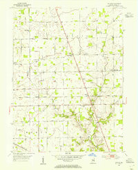
1953 Map of Rosston
USGS Topo · Published 1954About this map
Rosston and the surrounding agricultural landscapes of Union and Worth townships are defined by a grid of rural routes and crossroads settlements in the mid-1950s. The Central Indiana railroad cuts east-to-west through the center of the quadrangle, passing through Gadsden and serving as a primary transportation artery for this part of Boone County. The landscape is dotted with small community landmarks, particularly country churches like Lanes Chapel and Antioch Ch, which alongside numerous family burial grounds such as Parr-Jones Cem and Jones Cem, offer significant detail for genealogical research.
Find a feature on this map
29 named features on this map. Tap any name to fly to it.
Don’t see what you’re looking for? This feature index may not catch every label — zoom into the map to look around manually.
Map Details
Editions of this 1953 Rosston Map
2 editions found
Other maps of this area

1952 · Carmel
USGS Topo · 1:24,000

1953 · Westfield
USGS Topo · 1:24,000

1953 · Fayette
USGS Topo · 1:24,000

1953 · Rosston
USGS Topo · 1:24,000

1953 · Zionsville
USGS Topo · 1:24,000

1953 · Lebanon
USGS Topo · 1:24,000

1953 · Danville
USGS Topo · 1:250,000

1953 · Indianapolis
USGS Topo · 1:250,000

1955 · Danville
USGS Topo · 1:250,000

1956 · Danville
USGS Topo · 1:250,000