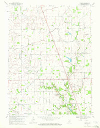
1969 Map of Rosston
USGS Topo · Published 1972About this map
Eagle Creek and its many man-made tributaries, including Padgett Ditch and Kreager Ditch, define the drainage of this Boone County landscape. Small rural settlements like Waugh, Big Springs, and Gadsden are connected by a rigid grid of numeric roads such as 400 North Road and 250 South Road. This system illustrates the late-century transition from isolated farmsteads toward more structured township organization.
Find a feature on this map
50 named features on this map. Tap any name to fly to it.
Don’t see what you’re looking for? This feature index may not catch every label — zoom into the map to look around manually.
Map Details
Editions of this 1969 Rosston Map
2 editions found
Other maps of this area

1952 · Carmel
USGS Topo · 1:24,000

1953 · Westfield
USGS Topo · 1:24,000

1953 · Fayette
USGS Topo · 1:24,000

1953 · Rosston
USGS Topo · 1:24,000

1953 · Zionsville
USGS Topo · 1:24,000

1953 · Lebanon
USGS Topo · 1:24,000

1953 · Danville
USGS Topo · 1:250,000

1953 · Indianapolis
USGS Topo · 1:250,000

1955 · Danville
USGS Topo · 1:250,000

1956 · Danville
USGS Topo · 1:250,000