
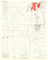
1949 Map of Roswell North
USGS Topo · Published 1949About this map
Roswell expanded into the Pecos Valley during the late 1940s, anchored by its namesake New Mexico Military Institute and the adjacent Roswell Municipal Airport. The city's residential and institutional growth is clearly mapped, featuring a dense network of neighborhood schools like North Hill Sch and Missouri Ave Sch, alongside religious landmarks such as St Andrews Ch and the Poor Clares Monastery. Beyond the urban core, the landscape reflects the region's dependence on groundwater, marked by numerous named artesian wells including the Berrendo Smith Artesian Recorder Well.
Find a feature on this map
64 named features on this map. Tap any name to fly to it.
Don’t see what you’re looking for? This feature index may not catch every label — zoom into the map to look around manually.
Map Details
Editions of this 1949 Roswell North Map
This is the sole edition of this map. No revisions or reprints were ever made.
Other maps of this area

1949 · Hondo Reservoir
USGS Topo · 1:24,000

1949 · Roswell South
USGS Topo · 1:24,000

1949 · Corn Ranch
USGS Topo · 1:24,000

1950 · Corn Ranch
USGS Topo · 1:24,000

1950 · South Spring
USGS Topo · 1:24,000

1950 · Bitter Lake
USGS Topo · 1:24,000

1955 · Roswell
USGS Topo · 1:250,000

1958 · Roswell
USGS Topo · 1:250,000

1962 · Roswell
USGS Topo · 1:250,000
1962 · Roswell South
USGS Topo · 1:24,000