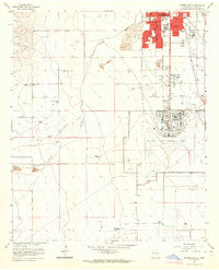
1962 Map of Roswell South
USGS Topo · Published 1964About this map
Roswell expands southward in the early 1960s, a period marked by the significant presence of Walker Air Force Base. The transition from the dense urban grid of the city to the surrounding agricultural landscape is clearly defined by several family-held properties, including Sacra Farm and Brown Bros Ranch. The southern residential districts are anchored by local institutions such as Monterey Sch and the extensive South Park Cemetery, while the northern portion of the base shows a developed network of athletic fields and a Golf Course. Hydrology in the area is dominated by the Rio Hondo, showing both its current course and a distinct Old Channel that suggests the historical shifting of the riverbed. This survey, revised in 1962, captures the intersection of military aviation history and the steady growth of the Roswell community during the Cold War era.
Find a feature on this map
28 named features on this map. Tap any name to fly to it.
Don’t see what you’re looking for? This feature index may not catch every label — zoom into the map to look around manually.
Map Details
Editions of this 1962 Roswell South Map
2 editions found
Other maps of this area

1949 · Hondo Reservoir
USGS Topo · 1:24,000

1949 · Peters Lake
USGS Topo · 1:24,000

1949 · Roswell North
USGS Topo · 1:24,000

1949 · Roswell South
USGS Topo · 1:24,000

1949 · Juan Lake
USGS Topo · 1:24,000

1949 · Corn Ranch
USGS Topo · 1:24,000

1950 · Dexter West
USGS Topo · 1:24,000

1950 · Corn Ranch
USGS Topo · 1:24,000

1950 · South Spring
USGS Topo · 1:24,000

1950 · Bitter Lake
USGS Topo · 1:24,000