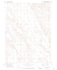
1972 Map of Roten Valley North
USGS Topo · Published 1975About this map
Stop Table and Schukar Table rise above the surrounding Custer County landscape, defining a series of prominent plateaus that shaped early agricultural settlement patterns. The 1970s terrain is marked by essential water management features like Stump Ditch, which follows the contours of Roten Valley to support local ranching. This area preserves several localized burial grounds, including the Stop Table Cem and the Sells Valley Cem, providing critical reference points for genealogical research in this part of Nebraska. The presence of the Morning Star Ch and numerous wells scattered across Hansen Table and Rock Island Table reflects a sparse but established community reliant on the distinct local topography and subsurface water resources of the Great Plains during the late twentieth century.
Find a feature on this map
11 named features on this map. Tap any name to fly to it.
Don’t see what you’re looking for? This feature index may not catch every label — zoom into the map to look around manually.
Map Details
Editions of this 1972 Roten Valley North Map
This is the sole edition of this map. No revisions or reprints were ever made.
Other maps of this area

1951 · Callaway
USGS Topo · 1:24,000

1951 · Oconto SW
USGS Topo · 1:24,000

1951 · Oconto NW
USGS Topo · 1:24,000

1954 · North Platte
USGS Topo · 1:250,000

1955 · Broken Bow
USGS Topo · 1:250,000

1956 · Broken Bow
USGS Topo · 1:250,000

1956 · North Platte
USGS Topo · 1:250,000

1957 · North Platte
USGS Topo · 1:250,000

1967 · North Platte
USGS Topo · 1:250,000
1972 · Odencranze Table South
USGS Topo · 1:24,000