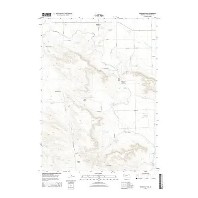
2014 Map of Roubadeau Pass
USGS Topo · Published 2014About this map
Hubbard Corner sits at the northern edge of this high plains landscape, where the flat irrigated fields of the Platte Valley meet the rising Escarpment. The complex engineering of the American West is visible here through the Gering and Fort Laramie Irrigation Tunnel and the winding Fort Laramie Canal, which trace the contours of the terrain to provide water for local agriculture. To the south, the topography shifts dramatically into the Wildcat Hills, a series of ridges and canyons defined by notable crossings like Roubadeau Pass and Rifle Sight Pass. This area, managed through an intricate system of reservoirs including Fanning Reservoir and Ouderkirk Reservoir, illustrates the intersection of natural geologic formations and human infrastructure. Names like Spook Canyon and Saddle Gap highlight the local character of these distinct landforms, while Cedar Valley and Carter Canyon provide sheltered breaks in the rugged upland terrain.
Find a feature on this map
46 named features on this map. Tap any name to fly to it.
Don’t see what you’re looking for? This feature index may not catch every label — zoom into the map to look around manually.
Map Details
Editions of this 2014 Roubadeau Pass Map
This is the sole edition of this map. No revisions or reprints were ever made.
Other maps of this area

1898 · Scotts Bluff
USGS Topo · 1:125,000

1954 · Scottsbluff
USGS Topo · 1:250,000

1958 · Scottsbluff
USGS Topo · 1:250,000

1960 · Stegall
USGS Topo · 1:24,000

1960 · Murray Lake
USGS Topo · 1:24,000

1963 · Scottsbluff South
USGS Topo · 1:24,000

1963 · Mitchell
USGS Topo · 1:24,000

1963 · Scottsbluff North
USGS Topo · 1:24,000
1963 · Morrill
USGS Topo · 1:24,000

1963 · Roubadeau Pass
USGS Topo · 1:24,000