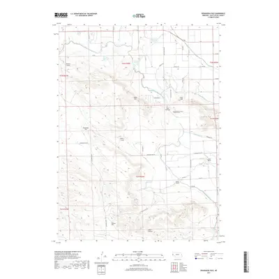
2017 Map of Roubadeau Pass
USGS Topo · Published 2017About this map
Wildcat Hills dominate the southern portion of this Nebraska landscape, creating a complex series of breaks and canyons that include Carter Canyon, Cedar Canyon, and the curiously named Spook Canyon. This topography is bisected by the historic Roubadeau Pass, a key corridor through the high ground. To the north and east, the elevation drops into a heavily engineered agricultural plain. The reliance on water management is evident through an extensive network of irrigation infrastructure, notably the Fort Laramie Canal, the Mitchell and Gering Canal, and several smaller waterways like the Gering Lateral. These canals wrap around the contours of the hills, feeding several upland storage sites including Stiver North Reservoir and Fanning Reservoir. A significant technical feature of this system is the Gering and Fort Laramie Irrigation Tunnel, which pierces through the heights near Rifle Sight to facilitate water movement across the divide.
Find a feature on this map
52 named features on this map. Tap any name to fly to it.
Don’t see what you’re looking for? This feature index may not catch every label — zoom into the map to look around manually.
Map Details
Editions of this 2017 Roubadeau Pass Map
This is the sole edition of this map. No revisions or reprints were ever made.
Other maps of this area

1898 · Scotts Bluff
USGS Topo · 1:125,000

1954 · Scottsbluff
USGS Topo · 1:250,000

1958 · Scottsbluff
USGS Topo · 1:250,000

1960 · Stegall
USGS Topo · 1:24,000

1960 · Murray Lake
USGS Topo · 1:24,000

1963 · Scottsbluff South
USGS Topo · 1:24,000

1963 · Mitchell
USGS Topo · 1:24,000

1963 · Scottsbluff North
USGS Topo · 1:24,000
1963 · Morrill
USGS Topo · 1:24,000

1963 · Roubadeau Pass
USGS Topo · 1:24,000