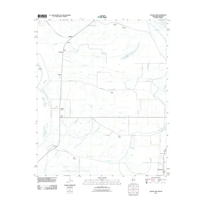
2011 Map of Round Lake
USGS Topo · Published 2011About this map
Round Lake sits at the heart of this Mississippi Delta landscape, where a complex network of bayous and sloughs defines the agricultural geography. The terrain is marked by the winding paths of the Hushpuckena River and Stokes Bayou, which drain the low-lying fields near settlements like Deeson and Rochdale. This 2011 survey captures the area's rural character, emphasizing the importance of family and community through numerous named burial grounds, including Jerusalem Cemetery and Saint Joseph Cemetery. Cultural and industrial landmarks such as Watts Field and the Mississippi River Levee illustrate the human efforts to manage and inhabit this flood-prone region. The map also traces legacy transportation routes like Old Hwy 61, which parallels the river's drainage patterns and connects the small hamlets and plantation outposts that have shaped Bolivar County's history.
Find a feature on this map
55 named features on this map. Tap any name to fly to it.
Don’t see what you’re looking for? This feature index may not catch every label — zoom into the map to look around manually.
Map Details
Editions of this 2011 Round Lake Map
This is the sole edition of this map. No revisions or reprints were ever made.
Other maps of this area

1930 · Mellwood
USGS Topo · 1:62,500

1931 · Drew
USGS Topo · 1:48,000

1935 · Clarksdale
USGS Topo · 1:62,500

1935 · Mound Bayou
USGS Topo · 1:62,500

1939 · Pace
USGS Topo · 1:62,500

1939 · Clarksdale
USGS Topo · 1:62,500

1939 · Mellwood
USGS Topo · 1:62,500

1948 · Helena
USGS Topo · 1:250,000

1950 · Helena
USGS Topo · 1:250,000

1953 · Greenwood
USGS Topo · 1:250,000