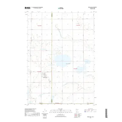
2019 Map of Round Lake
USGS Topo · Published 2019About this map
Round Lake anchors this southern Minnesota landscape where the high plateau of the Coteau des Prairies shapes the drainage of the region. This 2019 survey captures the highly engineered water system of Nobles and Jackson counties, where an intricate network of agricultural infrastructure like Judicial Ditch Number Nine, Judicial Ditch Number Thirteen, and County Ditch Number Ten regulates the flow across the prairie. These man-made channels connect natural water bodies such as Plum Lake and Illinois Lake, eventually feeding into the W Fork Little Sioux River.
Find a feature on this map
53 named features on this map. Tap any name to fly to it.
Don’t see what you’re looking for? This feature index may not catch every label — zoom into the map to look around manually.
Map Details
Editions of this 2019 Round Lake Map
This is the sole edition of this map. No revisions or reprints were ever made.
Other maps of this area

1954 · Fairmont
USGS Topo · 1:250,000

1958 · Fairmont
USGS Topo · 1:250,000

1960 · Brewster
USGS Topo · 1:24,000

1960 · Okabena
USGS Topo · 1:24,000

1960 · Worthington North
USGS Topo · 1:24,000

1960 · Worthington South
USGS Topo · 1:24,000

1960 · Round Lake
USGS Topo · 1:24,000

1960 · Sioux Valley
USGS Topo · 1:24,000

1970 · Harris
USGS Topo · 1:24,000
1970 · Lake Park
USGS Topo · 1:24,000