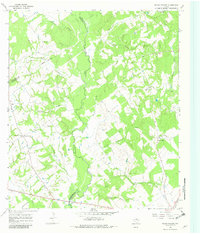
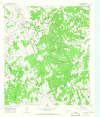
1966 Map of Round Prairie
USGS Topo · Published 1982About this map
The Navasota River winds through this central Texas landscape, marking the boundary where Leon, Limestone, and Robertson counties meet. This 1966 field-checked survey reveals a rural territory defined by its complex network of watercourses, including Birch Creek, Steele Creek, and Lambs Creek. The area is notably dense with family and community burial grounds, such as McKenzie Cem, Sansom Cem, and Grayson Cem, reflecting a long history of local settlement and genealogical depth. Small communities like Round Prairie and Seale are central to the region, situated near the Seale Round Prairie Cem. The presence of the Little Flock Ch and numerous dispersed homesteads suggests a quiet, church-and-agriculture focused society. The mapping of red dashed lines to indicate selected fence lines provides an additional layer of detail for researchers tracing land use and property divisions in the post-war era.
Find a feature on this map
31 named features on this map. Tap any name to fly to it.
Don’t see what you’re looking for? This feature index may not catch every label — zoom into the map to look around manually.
Map Details
Editions of this 1966 Round Prairie Map
Other maps of this area

1925 · Marquez No. 1
USGS Topo · 1:48,000

1927 · Marquez
USGS Topo · 1:62,500

1930 · Marquez
USGS Topo · 1:62,500

1954 · Waco
USGS Topo · 1:250,000

1955 · Waco
USGS Topo · 1:250,000

1956 · Jewett
USGS Topo · 1:62,500

1964 · Margie
USGS Topo · 1:24,000

1965 · Jewett
USGS Topo · 1:24,000
1965 · Marquez
USGS Topo · 1:24,000
1965 · Donie
USGS Topo · 1:24,000