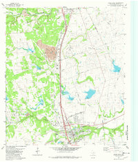
1982 Map of Round Rock
USGS Topo · Published 1982About this map
Brushy Creek and Onion Creek converge in this transition between the limestone hills and the blackland prairie just before the rapid suburban expansion of the 1980s. The landscape is defined by its deep geological features and industrial utility, most notably the Inner Space Cavern and a massive Quarry complex linked by a conveyor system. A dense network of transportation corridors, including the Georgetown Railroad Co and Missouri Pacific lines, underscores the importance of the local limestone and gravel industry.
Find a feature on this map
50 named features on this map. Tap any name to fly to it.
Don’t see what you’re looking for? This feature index may not catch every label — zoom into the map to look around manually.
Map Details
Editions of this 1982 Round Rock Map
This is the sole edition of this map. No revisions or reprints were ever made.
Other maps of this area

1893 · Georgetown
USGS Topo · 1:125,000

1896 · Austin
USGS Topo · 1:125,000

1897 · Austin
USGS Topo · 1:125,000

1910 · Austin
USGS Topo · 1:125,000

1925 · Georgetown 4-b
USGS Topo · 1:48,000

1925 · Georgetown 4-d
USGS Topo · 1:48,000

1928 · Round Rock
USGS Topo · 1:62,500

1932 · Mt. Bonnell
USGS Topo · 1:62,500

1949 · Round Rock
USGS Topo · 1:62,500

1951 · Round Rock
USGS Topo · 1:62,500