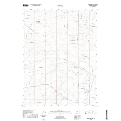
2017 Map of Round Top Lake
USGS Topo · Published 2017About this map
Round Top Lake sits at the heart of this high-plains landscape, where the elevation reaches significant peaks at Round Top and Stevenson Hill. The area is defined by its water management and agricultural heritage, shown through the presence of the John W Griffen Reservoir and King Reservoir. This region of Laramie County illustrates a transition from rural ranching roots to residential expansion, evidenced by local thoroughfares such as Experimental Farm Rd and Cattlemans Dr. Waterways like Crow Cr and Diamond Cr carve paths through the terrain, while road names like Quarter Circle Dr hint at the area's long-standing livestock history and land use patterns that persisted into the late 2010s.
Find a feature on this map
68 named features on this map. Tap any name to fly to it.
Don’t see what you’re looking for? This feature index may not catch every label — zoom into the map to look around manually.
Map Details
Editions of this 2017 Round Top Lake Map
This is the sole edition of this map. No revisions or reprints were ever made.
Other maps of this area

1905 · Sherman
USGS Topo · 1:125,000

1911 · Cheyenne
USGS Topo · 1:125,000

1914 · Cheyenne
USGS Topo · 1:125,000

1950 · Cheyenne
USGS Topo · 1:62,500

1954 · Cheyenne
USGS Topo · 1:250,000

1958 · Cheyenne
USGS Topo · 1:250,000

1961 · Round Top Lake
USGS Topo · 1:24,000

1961 · Cheyenne South
USGS Topo · 1:24,000
1961 · Borie
USGS Topo · 1:24,000

1961 · Cheyenne
USGS Topo · 1:62,500