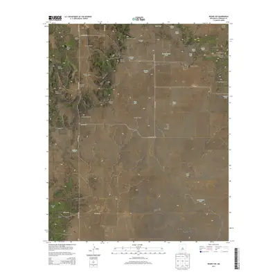
2013 Map of Round Top
USGS Topo · Published 2013About this map
The high desert landscape of Torrance County is anchored by Round Top, a prominent summit surrounded by a complex system of drainage draws and canyons. This 2013 survey reveals a territory defined by its water management, where numerous catchments like Gate Tank, Indian Tank, and Drum Tank support the ranching operations of the region. The Round Top Cem provides a focal point for genealogical interest, situated near the head of Rogers Canyon and Dead Dog Canyon. To the south, the terrain levels into the expansive Liberty Valley and the distinctive Mesa de los Jumanos. The presence of landmarks such as the Two-legged Windmill and various family-named features like Guy's Tank and Bessie Tank illustrate the human imprint on this arid environment, where county roads like Co Road 8065 and Co Road 8074 navigate the transition from mesas to valley floors.
Find a feature on this map
44 named features on this map. Tap any name to fly to it.
Don’t see what you’re looking for? This feature index may not catch every label — zoom into the map to look around manually.
Map Details
Editions of this 2013 Round Top Map
This is the sole edition of this map. No revisions or reprints were ever made.
Other maps of this area

1917 · Estancia
USGS Topo · 1:125,000

1954 · Fort Sumner
USGS Topo · 1:250,000

1954 · Socorro
USGS Topo · 1:250,000

1956 · Mountainair
USGS Topo · 1:62,500

1958 · Socorro
USGS Topo · 1:250,000

1958 · Fort Sumner
USGS Topo · 1:250,000

1962 · Socorro
USGS Topo · 1:250,000

1972 · Gran Quivira
USGS Topo · 1:24,000

1972 · Bigbee Draw
USGS Topo · 1:24,000
1972 · Mesa Draw
USGS Topo · 1:24,000