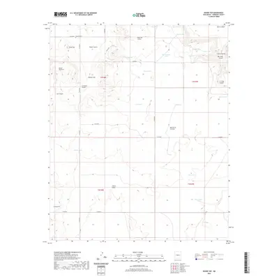
2020 Map of Round Top
USGS Topo · Published 2020About this map
Round Top Cem and the distinctive peak of Round Top overlook a complex landscape of drainage basins and high plains in Torrance County. The terrain is defined by a series of named draws and canyons, including Dead Dog Canyon, Rogers Canyon, and Crawford Canyon, which channel water toward numerous localized catchments. These tanks, such as Mesa Tank and Indian Tank, illustrate the critical importance of water management in this arid environment. To the south, the massive landform of Mesa de los Jumanos rises above Liberty Valley, marking a significant geological boundary. This survey provides a precise look at the rural infrastructure of the early 21st century, showing the network of county roads like Co RD b028 and Corliss RD that connect isolated landmarks such as Liberty Hill and various seasonal water bodies like Fain Lake and Cedar Lake.
Find a feature on this map
43 named features on this map. Tap any name to fly to it.
Don’t see what you’re looking for? This feature index may not catch every label — zoom into the map to look around manually.
Map Details
Editions of this 2020 Round Top Map
This is the sole edition of this map. No revisions or reprints were ever made.
Other maps of this area

1917 · Estancia
USGS Topo · 1:125,000

1954 · Fort Sumner
USGS Topo · 1:250,000

1954 · Socorro
USGS Topo · 1:250,000

1956 · Mountainair
USGS Topo · 1:62,500

1958 · Socorro
USGS Topo · 1:250,000

1958 · Fort Sumner
USGS Topo · 1:250,000

1962 · Socorro
USGS Topo · 1:250,000

1972 · Gran Quivira
USGS Topo · 1:24,000

1972 · Bigbee Draw
USGS Topo · 1:24,000
1972 · Mesa Draw
USGS Topo · 1:24,000