
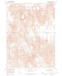
1951 Map of Round Valley
USGS Topo · Published 1953About this map
Lillian Creek meanders through the central hills of Custer County, shaping the agricultural landscape of central Nebraska in the early 1950s. This survey, part of the Department of the Interior's Missouri River Basin development program, captures the rural character of the region where local life centered around valley schools and small cemeteries. The settlement at Round Valley serves as a focal point in the eastern portion of the map, anchored by the Round Valley Cem. The topography is defined by distinct township-sized regions including Lillian, Garfield, and Broken Bow. Evidence of early community infrastructure is preserved through the locations of the Sargent Valley Sch and Swiss Valley Sch, illustrating the dispersed nature of education across the Sargent Valley and Swiss Valley at mid-century.
Find a feature on this map
14 named features on this map. Tap any name to fly to it.
Don’t see what you’re looking for? This feature index may not catch every label — zoom into the map to look around manually.
Map Details
Editions of this 1951 Round Valley Map
3 editions found

Other maps of this area

1951 · Broken Bow NE
USGS Topo · 1:24,000

1951 · Westerville
USGS Topo · 1:24,000

1951 · Lillian
USGS Topo · 1:24,000

1951 · Broken Bow
USGS Topo · 1:24,000

1951 · Walworth
USGS Topo · 1:24,000

1951 · Milburn
USGS Topo · 1:24,000

1952 · Sargent West
USGS Topo · 1:24,000

1952 · Sargent SW
USGS Topo · 1:24,000

1955 · Broken Bow
USGS Topo · 1:250,000

1956 · Broken Bow
USGS Topo · 1:250,000