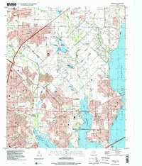
1995 Map of Rowlett
USGS Topo · Published 2002About this map
Lake Ray Hubbard dominates the eastern and southern edges of this area, defining the suburban expansion of Rowlett, Garland, and Sachse during the mid-1990s. The map illustrates a landscape in transition, where new residential developments and parks like Windsor Park and Salmon Park began to fill the spaces between older agricultural landmarks. Traces of the region's rural past remain visible through features such as Pleasant Valley Cem, Cottonwood Ch, and the small settlement of Liberty Grove. Several drainages, including Rowlett Creek and Muddy Creek, feed into the reservoir, creating a complex interface of suburban streets and natural waterways. This survey serves as a clear record of the infrastructure supporting North Texas growth, from the Garland Sewage Disposal plant to Rowlett High Sch, captured just as the neighboring towns were merging into a continuous urban corridor.
Find a feature on this map
46 named features on this map. Tap any name to fly to it.
Don’t see what you’re looking for? This feature index may not catch every label — zoom into the map to look around manually.
Map Details
Editions of this 1995 Rowlett Map
This is the sole edition of this map. No revisions or reprints were ever made.
Other maps of this area

1891 · Dallas
USGS Topo · 1:125,000

1893 · Dallas
USGS Topo · 1:125,000

1912 · Rockwall
USGS Topo · 1:31,680

1919 · Royse City
USGS Topo · 1:62,500

1924 · Farmersville 3-c
USGS Topo · 1:48,000

1924 · Mc Kinney 4-d
USGS Topo · 1:48,000

1929 · McKinney
USGS Topo · 1:62,500

1930 · Farmersville
USGS Topo · 1:62,500

1954 · Dallas
USGS Topo · 1:250,000

1954 · Sherman
USGS Topo · 1:250,000