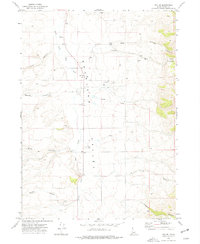
1973 Map of Roy NE
USGS Topo · Published 1977About this map
Rock Land Valley defines the central axis of this landscape, serving as a corridor for the South Fork Rock Creek and the primary north-south transit route. In the early 1970s, the area remained dominated by large-scale ranching and agriculture, evidenced by scattered Storage Bins and a Corral near the valley floor. The surrounding terrain is deeply incised by a series of drainages, including Hartley Canyon and Flint Canyon to the west, and the broad Portage Canyon to the northeast. Local industry is marked by several Gravel Pit sites, suggesting the ongoing maintenance of the rural road network. Numerous named Springs throughout the quadrangle highlight the critical importance of water sources in this high-desert environment, where the land transitions between steep canyon walls and open valley flats.
Find a feature on this map
17 named features on this map. Tap any name to fly to it.
Don’t see what you’re looking for? This feature index may not catch every label — zoom into the map to look around manually.
Map Details
Editions of this 1973 Roy NE Map
This is the sole edition of this map. No revisions or reprints were ever made.
Other maps of this area

1934 · Rockland
USGS Topo · 1:62,500

1937 · Rockland
USGS Topo · 1:62,500

1938 · Pauline
USGS Topo · 1:48,000

1944 · Arbon
USGS Topo · 1:62,500

1954 · Pocatello
USGS Topo · 1:250,000

1958 · Pocatello
USGS Topo · 1:250,000

1971 · Rockland East
USGS Topo · 1:24,000

1971 · Bannock Peak
USGS Topo · 1:24,000

1971 · Rockland West
USGS Topo · 1:24,000

1973 · Hartley Peak
USGS Topo · 1:24,000