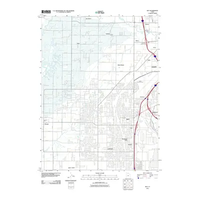
2011 Map of Roy
USGS Topo · Published 2011About this map
Roy and the surrounding Weber County settlements show a complex landscape of suburban expansion and agricultural persistence in the early 21st century. The Weber River and South Fork Weber River define the northern and eastern boundaries, managed by infrastructure like the Slaterville Diversion Dam. Historically significant sites like the Roy City Cemetery and Garland School remain embedded within modern neighborhoods, while the extensive grid of numbered roads—stretching from W 1150 S to W 800 N—illustrates the region's methodical development. Transport and commerce are anchored by the Ogden Municipal Airport and the industrial corridors near Relico and Evona. The presence of the Hooper Post Office and Roy Post Office highlights the distinct identities of these growing communities, while features such as Howard Slough and Smith Siding provide a look at the natural drainage and rail history that shaped the local topography.
Find a feature on this map
45 named features on this map. Tap any name to fly to it.
Don’t see what you’re looking for? This feature index may not catch every label — zoom into the map to look around manually.
Map Details
Editions of this 2011 Roy Map
This is the sole edition of this map. No revisions or reprints were ever made.
Other maps of this area

1954 · Antelope Island North
USGS Topo · 1:24,000

1954 · Ogden
USGS Topo · 1:250,000

1954 · Brigham City
USGS Topo · 1:250,000

1955 · Ogden
USGS Topo · 1:24,000

1955 · Plain City
USGS Topo · 1:24,000

1955 · Clearfield
USGS Topo · 1:24,000

1955 · Roy
USGS Topo · 1:24,000

1955 · Plain City SW
USGS Topo · 1:24,000

1955 · North Ogden
USGS Topo · 1:24,000

1955 · Kaysville
USGS Topo · 1:24,000