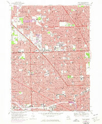
1968 Map of Royal Oak
USGS Topo · Published 1974About this map
The dense metropolitan grid spanning the Oakland Co Wayne Co line defines this mid-century portrait of suburban expansion and urban density. Centered on the sprawling Northland Shopping Center, the landscape is a complex network of residential blocks and institutional hubs. Educational and religious anchors like the University of Detroit, Marygrove College, and numerous parochial schools such as St Mary of Redford High Sch highlight the established community structure of the era. The presence of the Detroit Zoological Park and Rackham Golf Club provides significant open space amidst the heavy development. Major arterial routes, including the Northwestern Highway and 8 Mile Rd, serve as the primary conduits through Southfield, Berkley, and Detroit. Large memorial grounds like Woodlawn Cemetery and Evergreen Cem stand as quiet landmarks along the busy corridors near Palmer Park.
Find a feature on this map
69 named features on this map. Tap any name to fly to it.
Don’t see what you’re looking for? This feature index may not catch every label — zoom into the map to look around manually.
Map Details
Editions of this 1968 Royal Oak Map
4 editions found
Other maps of this area

1905 · Wayne
USGS Topo · 1:62,500

1905 · Detroit
USGS Topo · 1:62,500

1907 · Pontiac
USGS Topo · 1:62,500

1908 · Rochester
USGS Topo · 1:62,500

1912 · Wayne
USGS Topo · 1:62,500

1918 · Detroit
USGS Topo · 1:62,500

1924 · Detroit
USGS Topo · 1:62,500

1934 · Detroit
USGS Topo · 1:62,500

1936 · Warren
USGS Topo · 1:31,680

1936 · Inkster
USGS Topo · 1:31,680