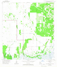
1956 Map of Royal Palm Ranger Station
USGS Topo · Published 1967About this map
Everglades National Park dominates this mid-century survey, showcasing the delicate balance between the protected wetlands and the encroaching agricultural grid of South Florida. The southwestern portion of the sheet is defined by the Taylor Slough drainage system, which feeds into distinct limestone and vegetation elevations known as keys, including Paradise Key, Parachute Key, and Pine Island. The Royal Palm Ranger Station serves as the primary administrative landmark within this wild landscape.
Find a feature on this map
14 named features on this map. Tap any name to fly to it.
Don’t see what you’re looking for? This feature index may not catch every label — zoom into the map to look around manually.
Map Details
Editions of this 1956 Royal Palm Ranger Station Map
4 editions found
Other maps of this area

1949 · Goulds
USGS Topo · 1:24,000

1950 · Homestead
USGS Topo · 1:24,000

1950 · Glades
USGS Topo · 1:24,000

1956 · Goulds
USGS Topo · 1:24,000

1956 · Grossman Hammock
USGS Topo · 1:24,000

1956 · Homestead
USGS Topo · 1:24,000

1956 · Royal Palm Ranger Station
USGS Topo · 1:24,000

1956 · Glades
USGS Topo · 1:24,000

1956 · Royal Palm Ranger Station SE
USGS Topo · 1:24,000

1956 · Miami
USGS Topo · 1:250,000