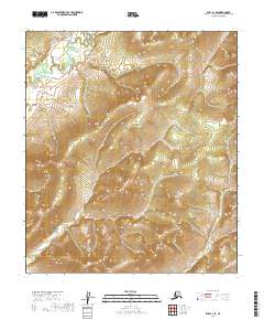
2019 Map of Ruby A-1 SE
USGS Topo · Published 2019About this map
Sethkokna River defines the northwestern reaches of this interior landscape, marking a winding watercourse through the vast public lands of the Yukon-Koyukuk Census Area. The terrain is shaped by the drainage systems of the river and the smaller Sischu Cr in the southeast, reflecting the untouched wilderness of central Alaska. Surveyed primarily to document the Public Land Survey System, the map detail focuses on the township and range grids, including t16s r28e and t17s r30e. This 2019 data provides a clear record of the hydrography and elevation contours in a region where human settlement is sparse and the natural geography of the river basins remains the primary feature.
Find a feature on this map
9 named features on this map. Tap any name to fly to it.
Don’t see what you’re looking for? This feature index may not catch every label — zoom into the map to look around manually.
Map Details
Editions of this 2019 Ruby A-1 SE Map
This is the sole edition of this map. No revisions or reprints were ever made.
Other maps of this area

1948 · Kantishna River
USGS Topo · 1:250,000

1950 · Medfra
USGS Topo · 1:250,000

1951 · Kantishna River
USGS Topo · 1:250,000

1951 · Ruby
USGS Topo · 1:250,000

1952 · Mount McKinley
USGS Topo · 1:250,000

1952 · Ruby A-1
USGS Topo · 1:63,360

1952 · Kantishna River
USGS Topo · 1:250,000

1952 · Kantishna River A-6
USGS Topo · 1:63,360

1952 · Ruby
USGS Topo · 1:250,000
1953 · Kantishna River A-6
USGS Topo · 1:63,360