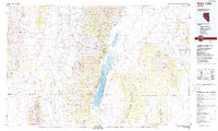
1988 Map of Ruby Lake
USGS Topo · Published 1988About this map
Ruby Mountains dominate this high-desert landscape in northeastern Nevada, dividing the Huntington Valley from the expansive Ruby Valley. This 1988 map illustrates a remote Great Basin ecosystem where the Ruby Lake National Wildlife Refuge and Franklin Lake serve as critical wetlands amidst the arid terrain. The map details the transition from the timbered heights of the Humboldt National Forest to the playas and alkaline flats of Dry Lake Flat and Alkali Flat. Small, isolated settlements like Jiggs, Shanty Town, and Indian Village are interconnected by a sparse network of roads, including 228 and 278, which skirt the edges of the Maverick Springs Range and the Diamond Mountains. Numerous seasonal drainages such as Mitchell Creek and Cassillini Creek flow from the peaks toward the basin floors, highlighting the vital relationship between the high-altitude snowpack and the valley's water resources.
Find a feature on this map
64 named features on this map. Tap any name to fly to it.
Don’t see what you’re looking for? This feature index may not catch every label — zoom into the map to look around manually.
Map Details
Editions of this 1988 Ruby Lake Map
2 editions found
Other maps of this area

1926 · Roberts Mountains
USGS Topo · 1:250,000

1929 · Roberts Mountains
USGS Topo · 1:250,000

1934 · Jiggs
USGS Topo · 1:125,000

1935 · Halleck
USGS Topo · 1:125,000

1937 · Mineral Hill
USGS Topo · 1:48,000

1937 · Jiggs
USGS Topo · 1:125,000

1943 · Mineral Hill
USGS Topo · 1:62,500

1949 · Garden Valley
USGS Topo · 1:62,500

1951 · Garden Valley
USGS Topo · 1:62,500

1952 · Dixie Flats
USGS Topo · 1:62,500