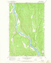
1967 Map of Ruby
USGS Topo · Published 1971About this map
The Pend Oreille River carves a deep path through this portion of the Colville National Forest, where 1960s industry and transport intersect with the remnants of earlier prospecting. Along the western bank, the Chicago Milwaukee St Paul and Pacific railroad follows the water's edge, passing through the small settlements of Blueslide and Ruby. Across the river, the landscape rises toward Ruby Mountain and Hanlon Mtn, intersected by a network of drainages including Le Clerc Creek and its various branches. The presence of Diamond City (Site) in Dry Canyon provides a specific point of interest for those tracking vanished mining camps, while active Mines and a Gravel Pit indicate the ongoing extraction of the region's resources during this era. A Ferry crossing and a Boat Ramp further underscore the river's role as a vital local corridor between the timbered slopes of Squirrel Meadow and Henry Brown Meadow.
Find a feature on this map
29 named features on this map. Tap any name to fly to it.
Don’t see what you’re looking for? This feature index may not catch every label — zoom into the map to look around manually.
Map Details
Editions of this 1967 Ruby Map
2 editions found
Other maps of this area

1934 · Metaline
USGS Topo · 1:125,000

1936 · Newport
USGS Topo · 1:96,000

1942 · Metaline
USGS Topo · 1:125,000

1942 · Newport
USGS Topo · 1:125,000

1958 · Sandpoint
USGS Topo · 1:250,000

1963 · Sandpoint
USGS Topo · 1:250,000

1967 · Timber Mtn.
USGS Topo · 1:24,000

1967 · Ione
USGS Topo · 1:24,000

1967 · Scotchman Lake
USGS Topo · 1:24,000

1967 · Monumental Mtn.
USGS Topo · 1:24,000