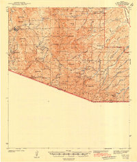
1942 Map of Ruby
USGS Topo · Published 1942About this map
Ruby stands as a focal point in this 1939 survey of the southern Arizona borderlands, a landscape defined by the Coronado National Forest and a series of sharp mountain ranges including the Tumacacori Mountains and Pajarito Mountains. The era's mining activity is heavily documented through local operations such as the Dos Amigos Mine, St Patrick Mine, and White Oak Mine. This region, documented just before the mid-century, reveals a network of remote ranching outposts like Bear Valley Ranch and Blankenship Ranch that relied on a complex system of springs and tanks, including Agua Blanca Spr and Tonto Tank. The presence of the Pena Blanca CCC Camp reflects Depression-era federal work projects in this high-desert terrain, while the Atascosa Lookout provides a strategic view over the canyons leading toward the United States-Mexico border.
Find a feature on this map
71 named features on this map. Tap any name to fly to it.
Don’t see what you’re looking for? This feature index may not catch every label — zoom into the map to look around manually.
Map Details
Editions of this 1942 Ruby Map
3 editions found
Other maps of this area

1904 · Patagonia
USGS Topo · 1:125,000

1905 · Patagonia
USGS Topo · 1:125,000

1905 · Nogales
USGS Topo · 1:125,000

1920 · Arivaca
USGS Topo · 1:125,000

1921 · Old Glory
USGS Topo · 1:125,000

1922 · Agus Caliente
USGS Topo · 1:62,500

1933 · Calabasas
USGS Topo · 1:62,500

1939 · Tubac
USGS Topo · 1:62,500

1941 · Arivaca
USGS Topo · 1:62,500

1942 · Ruby
USGS Topo · 1:62,500