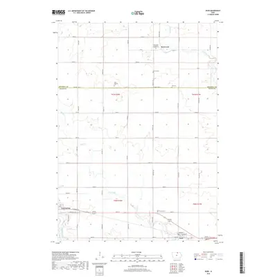
2018 Map of Rudd
USGS Topo · Published 2018About this map
Nora Springs and the village of Rudd anchor this Floyd County landscape, situated along a network of agricultural roads and waterways just south of the Mitchell County line. The terrain is defined by the meandering courses of the Shell Rock River, Rock Creek, and Flood Creek, which carve through the Iowa prairie. This area is particularly dense with pioneer-era markers, including the Rock Creek Evangelical Lutheran Cem and several family-named or location-specific burial grounds like the Oscar Peterson Cem, West End Cem, and Eden Cem. The layout of rural roads, such as Dancer Ave and Echo Ave, follows the rigid grid of the Public Land Survey System, while the southern portion of the map traces the residential streets and community landmarks of Nora Springs, including Park Cem and E Congress St.
Find a feature on this map
48 named features on this map. Tap any name to fly to it.
Don’t see what you’re looking for? This feature index may not catch every label — zoom into the map to look around manually.
Map Details
Editions of this 2018 Rudd Map
This is the sole edition of this map. No revisions or reprints were ever made.
Other maps of this area

1954 · Mason City
USGS Topo · 1:250,000

1957 · Mason City
USGS Topo · 1:250,000

1958 · Mason City
USGS Topo · 1:250,000

1959 · Mason City
USGS Topo · 1:62,500

1959 · Nora Springs
USGS Topo · 1:24,000

1959 · Mason City SE
USGS Topo · 1:24,000

1971 · Rockford
USGS Topo · 1:24,000

1971 · Orchard
USGS Topo · 1:24,000

1971 · Rudd
USGS Topo · 1:24,000
1971 · Roseville
USGS Topo · 1:24,000