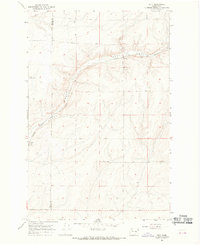
1967 Map of Ruff
USGS Topo · Published 1969About this map
Rocky Coulee dominates the northern landscape of this region along the border of Grant and Adams counties. The Chicago Milwaukee St Paul and Pacific railroad traces a path through the coulee, serving the small agricultural stops of Moody and Ruff. This late-1960s survey illustrates a rural economy deeply tied to dryland farming and transportation, with numerous wells and gravel pits scattered across the plateau. Local genealogy is anchored by the Schultz Memorial Cem in the northwest, while a dense network of family-named roads, including Arlt Road, Schoessler Road, and Griffith Road, highlights the established homesteads of the Columbia Basin. The terrain is characterized by the distinct basalt coulee formations, which dictated the movement of the early rail lines and subsequent road development.
Find a feature on this map
23 named features on this map. Tap any name to fly to it.
Don’t see what you’re looking for? This feature index may not catch every label — zoom into the map to look around manually.
Map Details
Editions of this 1967 Ruff Map
2 editions found
Other maps of this area

1923 · Wheeler
USGS Topo · 1:62,500

1925 · Wheeler
USGS Topo · 1:62,500

1925 · Schrag
USGS Topo · 1:62,500

1953 · Ritzville
USGS Topo · 1:250,000
1956 · Bassett Junction
USGS Topo · 1:24,000

1956 · Wheeler NE
USGS Topo · 1:24,000

1956 · Wilson Creek SE
USGS Topo · 1:24,000

1956 · Wilson Creek
USGS Topo · 1:62,500
1956 · Wheeler
USGS Topo · 1:62,500

1959 · Ritzville
USGS Topo · 1:250,000