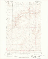
1967 Map of Ruff
USGS Topo · Published 1969About this map
The Chicago Milwaukee St Paul and Pacific railroad carves a winding path through this central Washington landscape, following the natural floor of Rocky Coulee. This 1967 survey captures a remote agrarian region defined by extensive farm roads named for local families, including Arlt Road, Schoessler Road, and Rosenoff Road. The small settlement of Ruff sits on the western edge of the quadrangle, while Moody serves as a localized hub further east along the rail line.
Find a feature on this map
21 named features on this map. Tap any name to fly to it.
Don’t see what you’re looking for? This feature index may not catch every label — zoom into the map to look around manually.
Map Details
Editions of this 1967 Ruff Map
2 editions found
Other maps of this area

1923 · Wheeler
USGS Topo · 1:62,500

1925 · Wheeler
USGS Topo · 1:62,500

1925 · Schrag
USGS Topo · 1:62,500

1953 · Ritzville
USGS Topo · 1:250,000
1956 · Bassett Junction
USGS Topo · 1:24,000

1956 · Wheeler NE
USGS Topo · 1:24,000

1956 · Wilson Creek SE
USGS Topo · 1:24,000

1956 · Wilson Creek
USGS Topo · 1:62,500
1956 · Wheeler
USGS Topo · 1:62,500

1959 · Ritzville
USGS Topo · 1:250,000