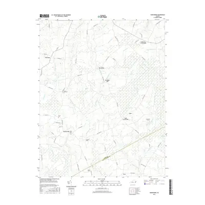
2016 Map of Runnymede
USGS Topo · Published 2016About this map
Mill Swamp and Passenger Swamp dominate this rural landscape on the border of Surry and Isle of Wight counties. The settlement pattern is defined by historic crossroads such as California Crossroads, Delk Crossroads, and the hamlet of Runnymede. Local history is preserved in several rural burial grounds, including Moores Swamp Cem, Cypress Cem, and Mount Moriah Cem, which serve as vital landmarks for genealogical research. The map captures the agricultural and timber character of the Tidewater region, featuring numerous pocosin wetlands like Cypress Pocosin, Willy Cox Pocosin, and Shrub Pocosin. The area’s light aviation history is visible at Beaver Dam Airpark and Wells Airport, while the legacy of early industry remains at Derrings Mill. Navigational features like Hundreds Bridge and the winding Blackwater River further define the connectivity of this woodland territory.
Find a feature on this map
65 named features on this map. Tap any name to fly to it.
Don’t see what you’re looking for? This feature index may not catch every label — zoom into the map to look around manually.
Map Details
Editions of this 2016 Runnymede Map
This is the sole edition of this map. No revisions or reprints were ever made.
Other maps of this area

1907 · Yorktown
USGS Topo · 1:62,500

1919 · Smithfield
USGS Topo · 1:62,500

1919 · Surry
USGS Topo · 1:62,500

1920 · Ivor
USGS Topo · 1:62,500

1943 · Yorktown
USGS Topo · 1:62,500

1943 · Richmond
USGS Topo · 1:250,000

1944 · Ivor
USGS Topo · 1:24,000

1944 · Smithfield
USGS Topo · 1:24,000

1944 · Raynor
USGS Topo · 1:24,000
1945 · Ivor
USGS Topo · 1:31,680