
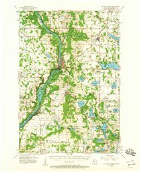
1950 Map of Rush City
USGS Topo · Published 1950About this map
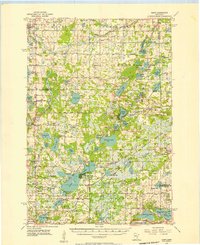
The St Croix River defines the western border of this landscape at the dawn of the 1950s, acting as the primary boundary between Minnesota and Wisconsin. Along its banks, the Rush City Ferry provides a vital river crossing point near the township of Randall. This area shows a transition from the agricultural clearings of Sterling and Anderson to the more wooded, swamp-prone sections of Grantsburg. The presence of the Logging RR in the northern reaches of the quadrangle suggests the continuing legacy of the region's timber industry, while the Northern Pacific railroad facilitates broader commerce. Local life is anchored by landmarks like the Pleasant Prairie Ch, Fish Lake Sch, and the Indian Cem, reflecting a long-settled community with deep roots in the river valley.
Find a feature on this map
27 named features on this map. Tap any name to fly to it.
Don’t see what you’re looking for? This feature index may not catch every label — zoom into the map to look around manually.
Map Details
Editions of this 1950 Rush City Map
This is the sole edition of this map. No revisions or reprints were ever made.
Other maps of this area

1900 · St Croix Dalles
USGS Topo · 1:62,500

1901 · St Croix Dalles
USGS Topo · 1:62,500

1950 · Grantsburg
USGS Topo · 1:48,000

1951 · Milltown
USGS Topo · 1:48,000

1953 · Stillwater
USGS Topo · 1:250,000
1955 · St. Croix Dalles
USGS Topo · 1:62,500
1955 · Rush City
USGS Topo · 1:62,500
1955 · Milltown
USGS Topo · 1:62,500
1955 · Forest Lake
USGS Topo · 1:62,500
1955 · Isanti
USGS Topo · 1:62,500