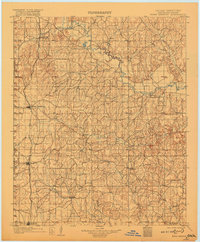
1902 Map of Rush Springs
USGS Topo · Published 1917About this map
The Washita River meanders through the heart of the Chickasaw Nation, anchoring a network of small agricultural settlements and early transport routes at the turn of the century. The Chicago Rock Island and Pacific railroad forms the primary corridor of development in the west, connecting the growing hubs of Rush Springs, Marlow, and Duncan. This 1902 survey illustrates the transition from tribal lands to organized territory, with the Indian Territory Oklahoma boundary line clearly demarcated. Away from the rail lines, smaller communities like Erin Springs, Alex, and Bradley are situated near the confluences of Rush Creek and the Little Washita River. The terrain is defined by a dense system of tributary creeks, including Roaring Creek and Wildcat Creek, which dictated the early settlement patterns and farm placement across these rolling prairies before Oklahoma achieved statehood.
Find a feature on this map
30 named features on this map. Tap any name to fly to it.
Don’t see what you’re looking for? This feature index may not catch every label — zoom into the map to look around manually.
Map Details
Editions of this 1902 Rush Springs Map
4 editions found
Other maps of this area

1893 · Norman
USGS Topo · 1:62,500

1898 · Purcell
USGS Topo · 1:125,000

1898 · Pauls Valley
USGS Topo · 1:125,000

1901 · Addington
USGS Topo · 1:125,000

1901 · Ardmore
USGS Topo · 1:125,000

1902 · Pauls Valley
USGS Topo · 1:125,000

1902 · Rush Springs
USGS Topo · 1:125,000

1904 · Chickasha
USGS Topo · 1:125,000

1918 · Ardmore
USGS Topo · 1:125,000

1936 · Norman
USGS Topo · 1:62,500