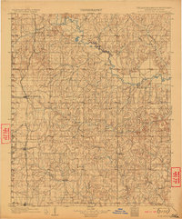
1902 Map of Rush Springs
USGS Topo · Published 1922About this map
The Old Indian Territory Oklahoma boundary line bisects the western edge of this territory, reflecting a landscape in transition at the close of the 19th century. Surveyed just before the turn of the century, the map documents the Chicago Rock Island and Pacific railroad as it cuts through the burgeoning settlements of Rush Springs, Marlow, and Duncan. To the northeast, the Washita River winds past Bradley and Erin Springs, defining a fertile valley that supported several early river towns. This period of the Chickasaw Nation's history is captured here in the placement of small post offices and rural centers like Hope, Wallville, and Robberson, which served the scattered agricultural community before Oklahoma achieved statehood. The network of creeks, such as Buckhorn Creek and Wild Horse Creek, illustrates the drainage patterns that dictated the early roads and property lines of the region.
Find a feature on this map
33 named features on this map. Tap any name to fly to it.
Don’t see what you’re looking for? This feature index may not catch every label — zoom into the map to look around manually.
Map Details
Editions of this 1902 Rush Springs Map
4 editions found
Other maps of this area

1893 · Norman
USGS Topo · 1:62,500

1898 · Purcell
USGS Topo · 1:125,000

1898 · Pauls Valley
USGS Topo · 1:125,000

1901 · Addington
USGS Topo · 1:125,000

1901 · Ardmore
USGS Topo · 1:125,000

1902 · Pauls Valley
USGS Topo · 1:125,000

1902 · Rush Springs
USGS Topo · 1:125,000

1904 · Chickasha
USGS Topo · 1:125,000

1918 · Ardmore
USGS Topo · 1:125,000

1936 · Norman
USGS Topo · 1:62,500