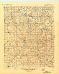
1902 Map of Rush Springs
USGS Topo · Published 1949About this map
The Old Indian Territory Oklahoma Boundary Line bisects this landscape, a remnant of the Chickasaw Nation’s western edge before the integration of Indian and Oklahoma Territories. Surveyed in 1898, the map illustrates a region transitioning from tribal jurisdiction to an organized agricultural and rail corridor. The Chicago Rock Island and Pacific RR runs north-to-south through the western portion, connecting the primary settlements of Rush Springs, Marlow, and Duncan.
Find a feature on this map
29 named features on this map. Tap any name to fly to it.
Don’t see what you’re looking for? This feature index may not catch every label — zoom into the map to look around manually.
Map Details
Editions of this 1902 Rush Springs Map
4 editions found
Other maps of this area

1893 · Norman
USGS Topo · 1:62,500

1898 · Purcell
USGS Topo · 1:125,000

1898 · Pauls Valley
USGS Topo · 1:125,000

1901 · Addington
USGS Topo · 1:125,000

1901 · Ardmore
USGS Topo · 1:125,000

1902 · Pauls Valley
USGS Topo · 1:125,000

1902 · Rush Springs
USGS Topo · 1:125,000

1904 · Chickasha
USGS Topo · 1:125,000

1918 · Ardmore
USGS Topo · 1:125,000

1936 · Norman
USGS Topo · 1:62,500