
1979 Map of Rush Valley
USGS Topo · Published 1979About this map
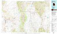
The Oquirrh Mountains and Onaqui Mountains dominate this late 1970s landscape, framing a region defined by high-desert basins and significant military installations. Large swaths of the valley floors are occupied by the Dugway Proving Ground and the Tooele Army Depot (South Area), illustrating the era's focus on national defense and strategic testing grounds.
Find a feature on this map
75 named features on this map. Tap any name to fly to it.
Don’t see what you’re looking for? This feature index may not catch every label — zoom into the map to look around manually.
Map Details
Editions of this 1979 Rush Valley Map
2 editions found
Other maps of this area

1885 · Salt Lake
USGS Topo · 1:250,000

1885 · Manti
USGS Topo · 1:250,000

1885 · Sevier Desert
USGS Topo · 1:250,000

1885 · Tooele Valley
USGS Topo · 1:250,000

1895 · Manti
USGS Topo · 1:250,000

1908 · Fish Springs
USGS Topo · 1:250,000

1910 · Fish Springs
USGS Topo · 1:250,000

1915 · Fairfield
USGS Topo · 1:62,500

1917 · Fairfield
USGS Topo · 1:62,500

1918 · Stockton
USGS Topo · 1:62,500