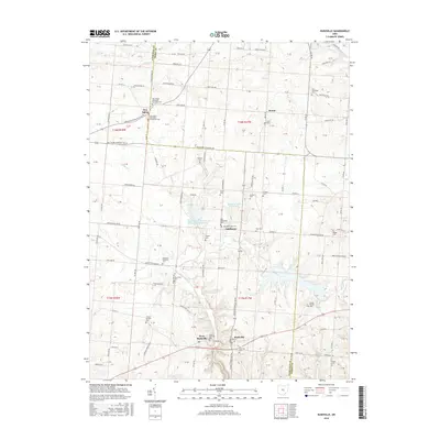
2016 Map of Rushville
USGS Topo · Published 2016About this map
The boundary between Fairfield and Perry Counties divides this rural landscape, which is defined by the headwaters of Little Rush Cr and Indian Cr. At the northern edge, the community of New Salem sits near the intersection of several historic township roads, accompanied by the New Salem Methodist Episcopal Cem and New Salem Methodist Protestant Cem. To the south, the village of Rushville and its neighbor West Rushville are prominent landmarks along the local highway network. The area is notable for its high density of family and community burial grounds, such as the Friend Ruffner Cem, Kaufman-Valentine Cem, and the Combs Family Cem. Modern hydrology is represented by the Rush Creek Watershed Structure 11 Reservoir and Rush Cr Lake, which have reshaped the drainage patterns of the upper Rush Creek basin.
Find a feature on this map
103 named features on this map. Tap any name to fly to it.
Don’t see what you’re looking for? This feature index may not catch every label — zoom into the map to look around manually.
Map Details
Editions of this 2016 Rushville Map
This is the sole edition of this map. No revisions or reprints were ever made.
Other maps of this area

1907 · Logan
USGS Topo · 1:62,500

1907 · Lancaster
USGS Topo · 1:62,500

1907 · Thurston
USGS Topo · 1:62,500

1909 · Thornville
USGS Topo · 1:62,500

1909 · Lancaster
USGS Topo · 1:62,500

1909 · Logan
USGS Topo · 1:62,500

1909 · Thurston
USGS Topo · 1:62,500

1947 · Columbus
USGS Topo · 1:250,000

1961 · Columbus
USGS Topo · 1:250,000
1961 · Millersport
USGS Topo · 1:24,000