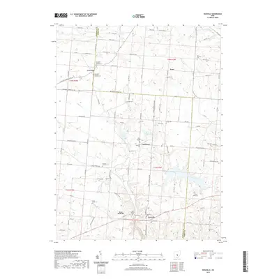
2019 Map of Rushville
USGS Topo · Published 2019About this map
Rushville and West Rushville sit along the southern edge of this landscape, established near the headwaters of Little Rush Creek. The region is defined by a dense network of family and community burial grounds, reflecting the deep ancestral roots of Fairfield County. From the New Salem Methodist Episcopal Cemetery in the north to the Combs Family Cemetery in the southeast, these sites alongside New Salem and Oakthorpe preserve the genealogy of the area's early farmsteaders. The terrain is carved by numerous waterways, including Indian Creek and Walnut Creek, while Rush Creek Lake and Memory Lanes Park Lake provide localized water management and recreation. Roads like Lancaster Thornville Road NE and Baltimore Somerset Road connect these rural hamlets, following the undulating rises between Perry and Fairfield counties.
Find a feature on this map
74 named features on this map. Tap any name to fly to it.
Don’t see what you’re looking for? This feature index may not catch every label — zoom into the map to look around manually.
Map Details
Editions of this 2019 Rushville Map
This is the sole edition of this map. No revisions or reprints were ever made.
Other maps of this area

1907 · Logan
USGS Topo · 1:62,500

1907 · Lancaster
USGS Topo · 1:62,500

1907 · Thurston
USGS Topo · 1:62,500

1909 · Thornville
USGS Topo · 1:62,500

1909 · Lancaster
USGS Topo · 1:62,500

1909 · Logan
USGS Topo · 1:62,500

1909 · Thurston
USGS Topo · 1:62,500

1947 · Columbus
USGS Topo · 1:250,000

1961 · Columbus
USGS Topo · 1:250,000
1961 · Millersport
USGS Topo · 1:24,000