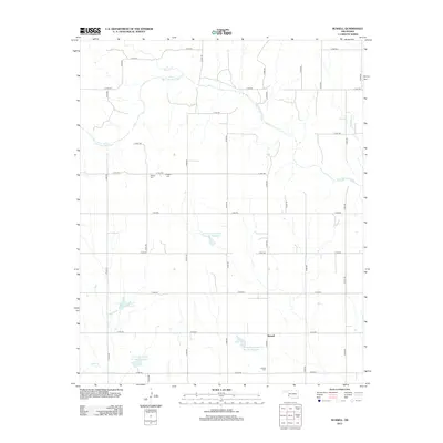
2012 Map of Russell
USGS Topo · Published 2012About this map
Salt Fork Red River meanders across this rural Greer County landscape, defining the hydrology of a region where water management is central to the local geography. The area is marked by a series of significant water control projects, including the Tri County Turkey Cr Site 4 Reservoir and Tri-County Turkey Cr Site 15 Reservoir, which illustrate the modern infrastructure required to support agricultural life. The settlement of Russell anchors the southeastern portion of the quadrangle, serving as a hub for the surrounding farmstead grid. For those tracing family histories in the area, several burial sites are documented here, including Wildcat Cem and Langford Cem situated near the river, as well as the Russell Cem located just west of the town center. The rigid road network, including routes like N 1840 RD, underscores the organized section-line development characteristic of western Oklahoma.
Find a feature on this map
32 named features on this map. Tap any name to fly to it.
Don’t see what you’re looking for? This feature index may not catch every label — zoom into the map to look around manually.
Map Details
Editions of this 2012 Russell Map
This is the sole edition of this map. No revisions or reprints were ever made.
Other maps of this area

1955 · Lawton
USGS Topo · 1:250,000
1961 · Hollis
USGS Topo · 1:62,500
1971 · Russell
USGS Topo · 1:24,000
1971 · Mangum North
USGS Topo · 1:24,000
1971 · Vinson
USGS Topo · 1:24,000
1971 · Mangum South
USGS Topo · 1:24,000
1971 · Mc Queen
USGS Topo · 1:24,000
1971 · Duke
USGS Topo · 1:24,000
1971 · Reed
USGS Topo · 1:24,000
1971 · Shrewder
USGS Topo · 1:24,000