
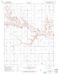
1968 Map of Russell Springs 3 SW
USGS Topo · Published 1969About this map
Ladder Creek carves a distinct, winding path across the landscape of Wichita Co. and Logan Co., defined by steep breaks and erosional gullies in an otherwise level High Plains terrain. This 1968 field-checked survey reveals a quiet agricultural district where life centered around the Parks Ch and the nearby Carwood Cem. The land is sparsely settled, with the township structure marked by section lines and occasional industrial activity, such as a Gravel Pit located along the creek's northern edge. The presence of numerous small stock ponds and depressions underscores the importance of water management in this part of western Kansas. To the south, the boundary with Leoti suggests the map's proximity to regional trade centers, while the label Beaver identifies a specific local area within the drainage basin of the creek.
Find a feature on this map
9 named features on this map. Tap any name to fly to it.
Don’t see what you’re looking for? This feature index may not catch every label — zoom into the map to look around manually.
Map Details
Editions of this 1968 Russell Springs 3 SW Map
2 editions found
Other maps of this area

1955 · Scott City
USGS Topo · 1:250,000

1958 · Scott City
USGS Topo · 1:250,000

1968 · Russell Springs 3 NW
USGS Topo · 1:24,000

1968 · Russell Springs 3 SE
USGS Topo · 1:24,000

1968 · Sharon Springs 4 NE
USGS Topo · 1:24,000

1968 · Russell Springs 3 NE
USGS Topo · 1:24,000

1970 · Sharon Springs 4 SE
USGS Topo · 1:24,000

1970 · Selkirk
USGS Topo · 1:24,000

1970 · Leoti
USGS Topo · 1:24,000

1970 · Leoti NW
USGS Topo · 1:24,000