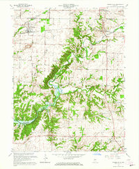
1963 Map of Russellville
USGS Topo · Published 1964About this map
Big Raccoon Creek and its complex network of tributaries, including Little Raccoon Creek and Bird Branch, define the landscape of northwestern Putnam County. This 1963 revision documents the presence of the Mansfield Reservoir, illustrating how local water management reshaped the valley's lower reaches. The agricultural and small-town character of the region is evident in the cluster of rural institutions, such as Hebron Ch and numerous family burial grounds like La Follett Cem and Sutherlin Cem. The Baltimore and Ohio railroad corridor passes through Russellville, which serves as a primary hub alongside smaller settlements like Fincastle, Morton, and Parkersburg. A notable modern addition to the cultural landscape near Morton is the Drive-in Theater, reflecting mid-century leisure patterns. The map also traces the boundary between Putnam and Montgomery counties, crossing through timbered creek bottoms and high-ground quarries.
Find a feature on this map
33 named features on this map. Tap any name to fly to it.
Don’t see what you’re looking for? This feature index may not catch every label — zoom into the map to look around manually.
Map Details
Editions of this 1963 Russellville Map
2 editions found
Other maps of this area

1949 · Alamo
USGS Topo · 1:24,000

1951 · Clinton Falls
USGS Topo · 1:24,000

1951 · Mansfield
USGS Topo · 1:24,000

1953 · Indianapolis
USGS Topo · 1:250,000

1955 · Russellville
USGS Topo · 1:24,000

1956 · Indianapolis
USGS Topo · 1:250,000

1956 · New Market
USGS Topo · 1:24,000

1957 · Indianapolis
USGS Topo · 1:250,000

1958 · Roachdale
USGS Topo · 1:24,000

1958 · Ladoga
USGS Topo · 1:24,000