
1958 Map of Ladoga
USGS Topo · Published 1959About this map
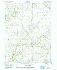
The town of Ladoga serves as the primary hub of this late-1950s landscape, positioned where the Monon railroad intersects with the winding course of Big Raccoon Creek. This mid-century survey reveals a rural landscape defined by its waterways and rail connections, with the New York Central railroad cutting through the northern reaches near Linnsburg and Walnut. Small rural nodes like Whitesville and Markey dot the grid of country roads, while the local drainage pattern is shaped by Cornstalk Creek, Offield Creek, and Rattlesnake Creek. Genealogists and local historians will find significant value in the placement of several family-named burial grounds, including Harshbarger Cem, Snow Cem, and Stoner Cem. Industrial features like a Chemical Co and Sewage Disposal plant near the town center reflect the period's infrastructure, while several gravel pits indicate the local reliance on the creek valley's natural resources.
Find a feature on this map
25 named features on this map. Tap any name to fly to it.
Don’t see what you’re looking for? This feature index may not catch every label — zoom into the map to look around manually.
Map Details
Editions of this 1958 Ladoga Map
2 editions found
Other maps of this area

1953 · Danville
USGS Topo · 1:250,000

1953 · Indianapolis
USGS Topo · 1:250,000

1955 · Danville
USGS Topo · 1:250,000

1955 · Russellville
USGS Topo · 1:24,000

1956 · Danville
USGS Topo · 1:250,000

1956 · Indianapolis
USGS Topo · 1:250,000

1956 · Crawfordsville
USGS Topo · 1:24,000

1956 · New Market
USGS Topo · 1:24,000

1957 · Indianapolis
USGS Topo · 1:250,000

1957 · New Ross
USGS Topo · 1:24,000