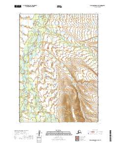
2019 Map of Russian Mission A-1 SE
USGS Topo · Published 2019About this map
The Aniak River meanders through this section of the Bethel Census Area, serving as the central hydrological feature of a landscape defined by its intricate drainage networks. This 2019 U.S. Geological Survey map illustrates a complex riparian environment where the Salmon River and Kipechuk River converge with the main channel, reflecting the seasonal shifts and alluvial processes of the Alaskan interior. Smaller tributaries like Timber Cr and Chicken Cr feed into these larger systems, tracing the local topography across the boundaries of t12n r56w and t11n r55w. The lack of man-made structures or settlements on this sheet emphasizes a wilderness state where the movement of water and the natural relief are the primary subjects of study for hydrologists and those interested in the pristine geography of the Kuskokwim River region.
Find a feature on this map
9 named features on this map. Tap any name to fly to it.
Don’t see what you’re looking for? This feature index may not catch every label — zoom into the map to look around manually.
Map Details
Editions of this 2019 Russian Mission A-1 SE Map
This is the sole edition of this map. No revisions or reprints were ever made.
Other maps of this area

1947 · Russian Mission
USGS Topo · 1:250,000

1950 · Russian Mission
USGS Topo · 1:250,000

1950 · Sleetmute
USGS Topo · 1:250,000

1950 · Bethel
USGS Topo · 1:250,000

1950 · Taylor Mountains
USGS Topo · 1:250,000

1951 · Taylor Mountains
USGS Topo · 1:250,000

1954 · Sleetmute
USGS Topo · 1:250,000

1954 · Taylor Mountains
USGS Topo · 1:250,000

1954 · Taylor Mountains D-8
USGS Topo · 1:63,360
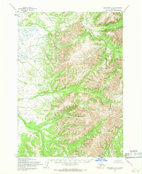
1954 · Sleetmute A-8
USGS Topo · 1:63,360